
- What is a landscape region and what are landforms?
- How are regional landscapes and landforms related to the rocks beneath?
- What are the landscape regions of the Pacific Northwest?
What is a landscape region?
A landscape region is an area throughout which the landscape has a distinctive style and geologic structure different from adjacent regions. Landscape regions are intrinsically tied to their geologic history. Geological events and processes that operate throughout the landscape region give it a distinctive set of landforms. For example, the landscape region known as the Columbia Plateau is a large flat region underlain by dark layers of rock and incised by steep-walled canyons called coulees. The coulees that cut the Columbia Plateau reveal a sequence of lavas that flooded the landscape millions of years ago. The coulees themselves are a result of more recent floods of a different kind--tremendous amounts of meltwater produced by glaciers of the ice age that ended by 12,000 years ago.
How is a landscape region related to the rocks beneath it?
The rocks that underlie a landscape region provide its foundation. They help determine the colors of the landscape, the shapes into which it erodes and the types of soils that form in the region. Study of the rocks also reveals a landscape region's geologic past--the materials and processes that formed it. Along with the climate of the area, the rock types of a landscape region and their susceptibility to erosion determine elevation and relief. For instance, the rocks of the Cascade Range tell a story of volcanic eruptions and intrusions of molten rock into the Earth's crust, which lifted the surface of the land and built a mountain range that was exposed to the sculpting forces of ice and water.
Each landform has its own geological story. In the study of geology, what is most important about landforms is what they reveal about geological processes. A landscape region made up of landforms such as steep ridges and deep stream valleys suggests that the region has undergone a significant amount of recent uplift. Being uplifted to a higher elevation exposes the region more to the forces of gravity and weather, which leads to rapid erosion
What are the landscape regions of the Pacific Northwest?

|
Basin and Range
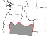
Prominent landforms: fault-block mountains; alluvial fans
The Basin and Range is a region of elongate mountain ranges separated by elongate valleys. The flanks of the ranges, which is the same thing as the margins of the basins, are underlain by normal faults. Normal faults are a type of fault that form where the Earth's crust is being stretched apart by tectonic forces.
Blue-Wallowa Mountains
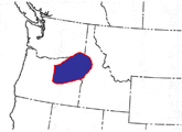
Prominent landforms: fault-block mountains; cirques (Wallowa Mtns.); glacial troughs (Wallowa Mtns.); stream valleys
The Blue Mountains and Wallowa Mountains anchor a belt of mountains from central Oregon to northeastern Oregon, southeastern Washington south of Walla Walla, and west central Idaho adjacent to Hells Canyon of the Snake River. The flanks of the Blue-Wallowa Mountains are blanketed by basalt flows of the Columbia River province along with older volcanic rock layers. Layers of sedimentary rocks in the area contain important fossils of Tertiary mammals and plants. The cores of the mountains contain accreted terranes and granite intrusions.
Cascade Range
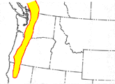
Prominent landforms: composite cones; calderas; cirques; glacial troughs; moraines; stream valleys
The Cascade Range is the volcanic arc of the Cascadia Subduction Zone. Only a few of the peaks in the Cascade Range, however, are volcanoes. The Cascade Range is a tectonic mountain range that is undergoing uplift due to creep, earthquakes, and igneous intrusion. Most of the high, jagged peaks of the Cascade Range consist of rocks other than volcanic rock, such as the intrusive igneous rocks of Mt. Stuart and the metamorphic rocks of Mt. Shuksan in Washington state.
The Cascade Range is capped by a sequence of tall, glacier-clad composite cone volcanoes, such as Mt. Rainier in Washington, Mt. Hood in Oregon, and Mt. Shasta in northern California.
Central Oregon Plateau
Prominent landforms: lava plateau; shield volcano; cinder cones; stream valleys
The Central Oregon Plateau, like the Columbia River Plateau and the Snake River Plain, is a lava plateau. However, the Central Oregon Plateau is underlain by a greater variety of volcanic layers than the Columbia River Plateau. The Central Oregon Plateau is capped by a variety of recently active volcanoes, including cinder cones and shield volcanoes. None of these types of young volcanoes appears on the Columbia Plateau. The Central Oregon Plateau is a younger volcanic region with a greater variety of volcanic rocks.
Coast Ranges
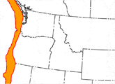
Prominent landforms: cirques (Olympic Mtns.); glacial troughs (Olympic Mtns.); stream valleys
The Coast Ranges, including the Olympic Mountains in Washington, are a region of rapid uplift of terranes that accreted in the Tertiary Period. The uplift occurs through a combination of creep, or gradual movement of the crust, and earthquakes. According to the geologic evidence, devastating subduction earthquakes occur along the coast every 200 to 500 years, the most recent great subduction earthquake happening 300 years ago.
The rapidly uplifting coast ranges capture much precipitation from the moist winds off the Pacific Ocean, leading to high levels of precipitation, rapid erosion, and steep mountains and valleys. You can sense that the landscape is young and "ragged" when you drive through the coast ranges and experience its steep, irregular hills and valleys covered by dense forests.
Unlike the Cascade Range, the Coast Ranges are non-volcanic. Most of the rocks in the Coast Ranges were oceanic crust before they became accreted to North America and uplifted into the Coast Ranges.
Columbia Plateau
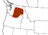
Prominent landforms: lava plateaus; anticlinal ridges; coulees; stream valleys
The Columbia Plateau of eastern Washington and bordering areas of Idaho and Oregon is an elevated region that is relatively flat, even though it has some zones of ridges and hills and is cut here and there by river gorges and dry coulees. Beneath the soil, much of the Columbia Plateau consists of basalt, which is dark, solidified lava. Some parts of the Columbia Plateau, such as the Palouse, are covered by loess.
The Channeled Scablands (also called the Channeled Scabland) is the name for a world-famous landscape on the Columbia Plateau. This landscape is marked by zones of steep-walled dry canyons (coulees) and places where the loess that formerly covered the basalt layers appears to have been scoured away, revealing the rough basaltic rocks (scabs).
The coulees that cut across the Columbia Plateau reveal a sequence of lavas that covered the the landscape. This is the Columbia River Basalt, of Miocene age. Most of the eruptions of what is called the Columbia River flood basalt happened 14-17 million years ago. The coulees themselves, eroded into the basalt much later, are a result of much more recent floods of a completely different kind: tremendous amounts of meltwater produced by glaciers of the Pleistoene epoch ice ages, which ended around 12,000 years ago.
The Channeled Scablands were shown by a geologist named J Harlan Bretz, going against the accepted theory that such giant floods were not possible, who starting in the 1920s published evidence he collected from field work that he and his students painstakingly conducted across eastern Washington, which demonstrated that the Channeled Scablands formed as the result of super-gigantic floods, the last round of which occurred near the end of the last ice age (12,000-30,000 years ago).
Most of the flooding took place when a large lake we now call glacial Lake Missoula, which had become impounded by a dam of glacial ice in the Idaho Panhandle, east of Spokane, breached the dam and surged across eastern Washington. Because as long as the ice sheet was active it would flow forward to fill the valley in Idaho, dam the river, and form the giant lake again, the flooding happened many times.
The huge volume of floodwater, in the pathways the water found across the Columbia Plateau, scoured away the loess to form the scablands, eroded channels up to many hundreds of feet deep into the basalt, forming the coulees, and transported and deposited the eroded sediment, forming giant flood bars (huge, boulder-laden sand bars) with giant sediment ripples on them. This landscape of scablands, coulees, and deposits of water-lain sediments that in extreme cases have boulders up to 30 feet in diameter on them, are the Channeled Scablands.
The scale of the floods that formed the Channeled Scablands can be difficult to imagine. The best views of the Channeled Scablands are from an airplane or even a satellite, where the huge scale of the floods and their effects can be more easily recognized and appreciated. These cataclysms dwarf any flood humans have witnessed since 12,000 years ago, which was before writing, agriculture, and cities were invented by various peoples on Earth.
Native Americans might have witnessed, and some unfortunate ones might have been swept away by, the giant floods that roared across eastern Washington and down the Columbia River to the Pacific Ocean late in the Pleistocene epoch. However, so far, we have no geologic nor archeologic evidence to support that speculation.
Okanogan Highlands
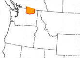
Prominent landforms: fault-block mountains; metamorphic core complex; moraines
The Okanogan Highlands form a transition zone from the North Cascades to the Rocky Mountains. The highlands are between the Methow Valley and the Columbia River, along the border of Canada and Washington State. The region consists of hills and moderately high mountains, cut by several low river valleys. The rocks are a mixture of gneiss, granite, volcanic rocks, sedimentary rocks, and accreted terranes.
Puget-Willamette Lowland
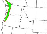
Prominent landforms: moraines (Puget Sound area); glacial troughs (Puget Sound area); drumlinoids (Puget Sound area); stream valleys; floodplains
The Puget-Willamette Lowland is the low area between the Cascade Range and the coast ranges. The land there has tended to become covered by sediments from rivers, and lately an arm of the ocean in the form of Puget Sound. In the Puget Sound area, the land was eroded and extensively mantled by glacial drift from continental glaciers that flowed out of the Canadian mountains during the Pleistocene.
Rocky Mountains
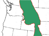
Prominent landforms: fault-block mountains; stream valleys
The Rocky Mountains are a broad region of uplifted fault-block mountain ranges and wide valleys that also have high elevations, even though they are lower than the surrounding mountains.
Snake River Plain
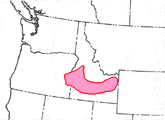
Prominent landforms: lava plateau; stream valleys; calderas
The Snake River Plain in Idaho is another relatively flat region underlain by volcanic rocks. However, the volcanic rocks beneath the Snake River Plain are not only basalt. The region also has a lot of volcanic rocks that are light- colored, including rhyolite and ash flow tuff.
Glossary terms that appear on this page: coulee; lava; glacier; fault-block mountain; alluvial fan; normal fault; tectonic; cirque; glacial trough; stream valley; basalt; sedimentary rocks; granite; composite cone; caldera; moraine; creep; intrusive; igneous rocks; metamorphic rocks; lava plateau; shield volcano; cinder cone; volcanic rocks; loess; terrane; subduction earthquake; anticlinal ridge; metamorphic core complex; gneiss; drumlinoid; floodplain; glacial drift; continental glacier; rhyolite; ash flow tuff
Focus Page #1--Landscape Regions
© 2001 Ralph L. Dawes, Ph.D. and Cheryl D. Dawes
updated: 6/16/13